Navigating the History of Trinity’s Campus Using a Digital Story Map
Content
Story
Posted
By
Bailey McKeon ’22
Category
Trinity Community
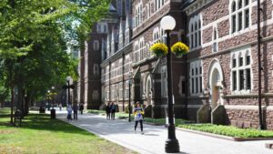
A digital story map developed in the past year by Tess Meagher ’20 and Trinity instructional technologist Cheryl Cape showcases the evolution of Trinity College’s campus. The interactive story map, complete with aerial photos of campus and close-up pictures of buildings, documents the school’s unique physical history.
Cheryl Cape
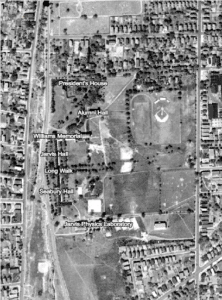
Cape’s idea for a digital story map originated in an effort to portray stories submitted by alumni for the Women at the Summit celebration marking 50 years of coeducation at Trinity. Although Cape ultimately decided that a story map was not the best way to display alumni stories, she remained fascinated by the aerial images of campus and intrigued by the possibility of using story mapping as a tool for project design. After organizing the map using these aerial images, taken between 1934 and 1986, and photos of the buildings through these times, Cape turned to Meagher, a student technology assistant and a history and political science double major, to aid in transitioning the project to showcase Trinity’s history.
Tess Meagher
Meagher first spent three months researching Trinity’s past by reading books from the library about Trinity’s history. “I enjoyed the research because I was finding out new information all of the time, which was fun,” Meagher said. Once she compiled detailed notes of each campus building for a particular year, she constructed an overarching narrative for that year, a narrative she would highlight on the story map. Then, she dug into books, online archives, and boxes in the Watkinson Library to find more images of the campus and the buildings that shaped it. Meagher, with her research and collected images, added pop-ups to Cape’s story map that describe the rich history of the buildings and note how the campus has evolved over time.
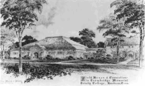
Memorial Field House in 1948
“We titled the story map ‘Snapshots in Time’ because the time that each picture or aerial image was taken will never come back,” Cape said. “That view of the campus from that day is gone forever. To be able to see it, not as a drawing or as a conceptual thing, but to see it as a photograph, is incredible.”
Although Meagher and Cape are showcasing their story map online, Cape said a project like this is never finished. She envisions future student technology assistants, now that Meagher has graduated, growing the site by increasing the number of years displayed; adding more galleries for iconic campus buildings, such as the Chapel; and uploading the original architectural drawings for the campus. “I’m excited to show the original architectural drawings because the physical campus constructed is very different from the architectural plans,” Cape said.
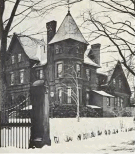
The president’s house in the mid-1880s (now the English building)
Meagher said the architectural drawings would be an important addition to the site. “The Long Walk itself was intended to go the other direction,” Meagher said. “The campus is rotated 90 degrees from the original architectural plans. When I would walk around campus after discovering this, I thought about the campus layout more and imagined how Trinity’s campus would have impacted Hartford had the construction of Trinity matched the original plans. Everything would be organized differently.”
Aerial Photo from 1934
Meagher said she hopes that Cape will add pop-ups recognizing the renaming of Seabury and Wheaton Halls and explaining the significance of this historical moment. Cape said she intends to do this and is thankful that the design of the project enables her to keep up with history as it occurs. “I love the dynamic quality of the digital story map,” Cape said. “A digital project like this is very different from a static book in that it can evolve and change as things change. It’s important to keep track of the changes.”
While Meagher and Cape said they are excited to share a resource for the Trinity community to learn more about the history of Trinity, they also anticipate that their use of a story map for project design will inspire others to model their own projects on story maps in the future.
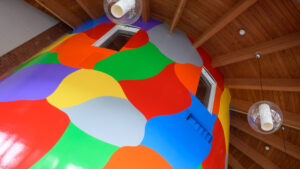
A striking and colorful piece of art in the Cornelia Center created by conceptual artist Sol LeWitt underwent a thorough restoration this summer, nearly three decades after its installation.
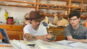
Trinity College students Augustin Millet ’28 and Noah R. Turner ’27 spent a month conducting archaeological research in Greece this summer alongside Associate Professor of Classical Studies Martha K. Risser.
A highlight from June was Reunion Weekend, which included Ideas Fest and the Athletics Hall of Fame induction. Restorations and repairs continued across campus, and the concrete was poured for the new Elting Center for Innovation and Entrepreneurship.
Reunion Weekend 2026 welcomed back to campus nearly 1,000 Bantams from class years ending in 1 and 6. A highlight of the weekend’s programming was Ideas Fest 2026.